Satellite Remote Sensing - Context

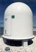
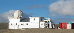
The Maurice Lamontagne Institute remote sensing laboratory operates three satellite image receiving stations (Mont-Joli, Victoria and Resolute Bay) allowing the acquisition of National Oceanic and Atmospheric Administration (NOAA) weather satellite data and making it possible to present a complete coverage of the three oceans surrounding Canada.
These data are processed to calculate sea surface temperatures and are used for oceanographic research and for ecosystem monitoring. These images allow the monitoring of the evolution of various physical processes and their coupling to biological processes. The images acquired during each satellite pass are used to generate a complete daily national coverage as well as averages over periods of several days.
Image processing (passes)
After their acquisition, the images are filtered to eliminate the presence of clouds and ice and a land mask is applied. Images are georeferenced using a first approximation based on orbital parameters and refined using an automatic correspondence between ground landmarks from the coastline on the images and a digital chart. Generally, the georeferencing precision is of the order of one pixel (1.1 km). Sea surface temperatures are calculated using a split-window type algorithm using thermal channels from the Advanced Very High Resolution Radiometer (AVHRR). Different algorithms are used for day and night captured images. The Terascan software (Seaspace Corporation) is use to georeference the images and to calculate sea surface temperatures. Products generated during processing are validated against in situ data acquired by the thermograph network.
Temporal averages

As clouds block the observation of the sea surface, it is normal to generate composite images to obtain cloud-free products. The most used technique is a temporal average over a more or less extensive period that depends on the local cloud cover characteristics. For the Canadian products, the generation of daily composite images was selected and is used to generate n-days composites. This allows a good temporal resolution while maintaining a low percentage of cloud cover. The composite images are generated using the individual images. Images for which the georeferencing quality is not acceptable are not included into the calculation of the means. The means are generated using available data from all operational satellites and include day and night data.
Laboratory Activities

Besides sea surface temperature operational activities, the remote sensing laboratory is engaged in a variety of research projects using remote sensing data as a basis for understanding marine ecosystems. The laboratory leads an ocean optics research project aiming at understanding the spatial and temporal variability of variables affecting the sea color (dissolved and particulate matter, phytoplankton).
The objectives of this project initiated in 1997 are to validate the actual operational ocean color algorithms for the remote sensing assessment of chlorophyll and the development of new local algorithms reflecting better the particular conditions of the St. Lawrence Estuary and Gulf. Once these objectives are reached, it will become possible to better use ocean color remote sensing images for the assessment and the monitoring of phytoplankton biomass. This project is carried out with the collaboration of the following partners: Sherbrooke University, l’Institut des sciences de la mer de Rimouski and the York University. The oceanographic buoy network is also a part of the project as the buoys are equipped with radiometers allowing the measurement of remote sensing reflectance simultaneous to satellite passes.
Publication Directory: To get a copy, please contact Pierre.Larouche@dfo-mpo.gc.ca.


